Here are some recent, confirmed road closures and alerts in California to know before you plan your trip. Routes can change fast, always double-check sources like Caltrans, 511, or local county sites just before you leave.
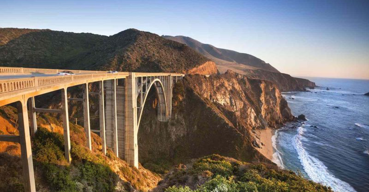
1. Highway 1, Big Sur (Rocky Creek & Regent’s Slide area)
Imagine staring out at the Pacific, only to find your drive cut short by a landslide. That’s the reality for travelers along Highway 1 near Rocky Creek and Regent’s Slide. This stretch, between north of Lucia and south of Esalen, remains partly closed, with some segments under repair for weeks or even months after winter storms battered the coast.
As of September 2025, the Regent’s Slide closure remains in effect, with no definite reopening date. Caltrans continues repair and stabilization work.
Locals and road crews work around the clock to reopen what many call California’s most scenic route. But for now, you’ll need to plan carefully. Recent closures ranged from overnight blocks near Carmel to lengthy daytime restrictions.
If your heart is set on that iconic drive, be sure to check the Monterey County site and Caltrans QuickMap each morning before heading out. There’s a silver lining: detours through inland valleys offer a different, quieter view of California’s wild side. Use the HOW2HWY1 guide for tips and keep an eye out for changing conditions, nature rarely sticks to a schedule here.
2. Monterey County Road Closures (Carmel Valley / Laurel Grade / Elkhorn Rd area)
Some mornings in Monterey County, the sound of roadwork echoes across Carmel Valley and Laurel Grade. Lane reductions and closures are frequent in these pockets of wine country, with repairs stretching from quiet, winding roads to more traveled routes like Elkhorn Road.
These aren’t just short interruptions. Some closures are indefinite, while others run Monday through Friday during daylight hours. That means locals and visitors alike must allow extra travel time and stay flexible, especially when detours wind through unfamiliar territory.
What keeps these roads in flux? Rain, aging infrastructure, and ongoing upgrades all play a role. Before your next trip, consult the Monterey County “Traffic Advisories” map. You might stumble onto a backroad you never meant to find, sometimes, the unexpected becomes the highlight of your journey in this historic region.
3. Pacific Coast Highway (PCH) Lane Reductions (Topanga Canyon Blvd to Las Flores Canyon Rd)
Sun-soaked stretches of the Pacific Coast Highway promise iconic drives, but right now, patience is your best companion. Between Topanga Canyon Boulevard and Las Flores Canyon Road, ongoing recovery and utility work has squeezed the PCH into a single lane in both directions.
Weekdays see the southbound side restricted from 9 a.m. to 5 p.m., while weekends bring single-lane traffic in both directions from dawn to late afternoon. These lane reductions will last through September, and the backup can be significant, especially on sunny weekends when everyone heads for the coast.
If you’re headed to Malibu or Santa Monica, check traffic updates before you go. Consider alternate times or inland routes if you crave a smoother trip. The work crews are out for a reason, these are essential repairs after storms and heavy use. The payoff: safer drives and even more beautiful views in the long run.
4. I-405 Sepulveda Pass Lane Reductions (September 5-8, 2025)
For those who know Los Angeles, the Sepulveda Pass is notorious for traffic. This September, it’s about to get even trickier when I-405 reduces to three lanes each way for maintenance from the 5th to the 8th.
Ramp closures and rerouted exits will challenge your usual shortcuts and routines. Public transit may be your friend, or perhaps it’s time to try that podcast you’ve been saving if you’re caught in the snarl.
City agencies urge everyone to map out alternate routes in advance. Even a quick trip across town could take twice as long. If you brave the pass, expect a new appreciation for patience, and maybe a good story for your friends about LA’s legendary commutes.
5. Great Highway Closure in San Francisco (Sunset Dunes Park)
Walking along San Francisco’s Great Highway now feels different, no car engines, just waves and wind. In 2025, the city officially closed a two-mile stretch to vehicles, turning it into Sunset Dunes Park. Families and cyclists have reclaimed this scenic road, trading tires for sneakers and surfboards.
This closure isn’t temporary. In April 2025, the City officially transformed the upper two-mile section of the Great Highway into Sunset Dunes Park, permanently banning cars on that portion. The change came through Proposition K, which voters approved in November 2024. If you need to drive, plan a detour through adjacent neighborhoods, Sunset Dunes now offers a space designed for walking, cycling, and community gathering.
Whether you’re a local or first-time visitor, the new park offers room to breathe, picnic, or simply watch the Pacific. If you need to drive, plan a detour through adjacent neighborhoods. For many, this closure marks a refreshing pause from urban rush, proof that sometimes, California’s best roads are walked, not driven.
Dear Reader: This page may contain affiliate links which may earn a commission if you click through and make a purchase. Our independent journalism is not influenced by any advertiser or commercial initiative unless it is clearly marked as sponsored content. As travel products change, please be sure to reconfirm all details and stay up to date with current events to ensure a safe and successful trip.