I came to Louisiana looking for music, food, and wide open water, but a quiet rumor tugged me into the marsh. Locals spoke lightly about a family park swallowed by reeds and time, where laughter once bounced off cypress trunks. Curiosity won, and I followed the levee roads to where maps fade. What I found felt personal and real, a place that still tells its story if you pause and listen.
The Park That Vanished into the Swamp
I first learned about the site through parish records and news archives that tracked its sudden fall. The park opened as Jazzland, then operated as Six Flags New Orleans, and closed after Hurricane Katrina. In 2025, city records and Bayou Phoenix project updates note that site cleanup, drainage work, and infrastructure stabilization have received funded contracts as part of the long-term redevelopment now underway.
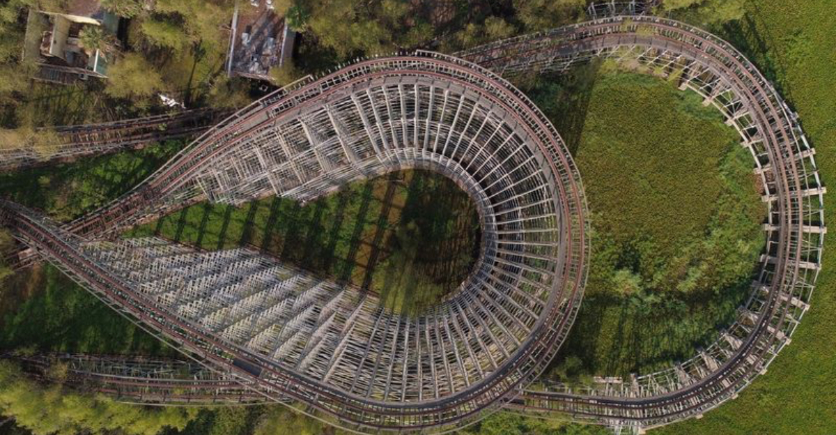
Security patrols watch the grounds, and signs warn against trespassing. I stood outside the fence and listened to wind move through cane and alder. The skyline showed coaster frames like ribs above the trees. Water pooled in low spots and egrets hunted around culverts.
You can still see the main gate from the public road. It looks smaller than it did in old photos. Every squeak from loose sheet metal echoes across the flat. The swamp presses in and softens the hard lines left behind. That pressure tells you the park did not simply shut down. It dissolved into the landscape.
How Families Once Filled Its Rides
I spoke with residents who remembered summer outings when Jazzland hosted regional festivals. Newspapers from the early years listed concerts, school trips, and marching band days. The wooden walkways rang with steps, and heat rose from the asphalt near the coaster queue.
Old TV segments still live online and show shaded picnic areas and a small kiddie zone. The design focused on local themes and nods to the city’s music roots. People planned birthdays here, then caught late dinners in nearby neighborhoods. I read ride rosters from archived brochures to match names with the frames I saw beyond the fence.
Those memories surfaced with every distant gull call. The park once felt like a simple promise: easy fun, clear routes, loud colors. Louisiana families came for predictable good days. That predictability now sits behind chain link and vines. The contrast sharpened my respect for the time it served the community well.
When Nature Began to Reclaim the Grounds
After the closure, seasonal floods leached minerals into the soil and encouraged willow and cattail growth. City and environmental reports note how water levels and salinity shape regrowth here. I watched dragonflies stitch blue threads across puddles near the roadbed. Grasses colonized cracks in concrete faster than I expected. Birds scout the coaster supports for perches.
At dusk, frogs call from culverts in a steady chorus. Studies on coastal transition zones in Louisiana explain this quick surge of life after disturbance. The park’s built edges turned into habitat, not quickly but decisively. I took notes on plant species visible from legal vantage points.
The line between garden and wild disappeared. That shift does not romanticize decay. It shows how the region’s ecology responds to open space with relentless growth. Nature did not ask permission here. It simply filled every empty niche and kept going.
The Storms and Floods That Sealed Its Fate
Public records and national reporting confirm Hurricane Katrina flooded the site and halted operations. The city later terminated the lease, and the property sat in limbo. I reviewed official timelines to verify dates and decisions. Flood maps show how surge and rainfall overwhelmed the area. Maintenance crews could not restore key systems, and corrosion set in.
Insurance and litigation stretched over years. Proposals surfaced, but none reached full build out. In Louisiana, each storm season brings fresh reminders of risk along low ground. I traced the levee lines that protect nearby neighborhoods today.
Water management has improved but still faces large challenges. The park became a case study in flood exposure. The evidence stands in twisted rails and sun-bleached signs. You can read the history by following the waterlines.
What Locals Remember About Its Glory Days
I met residents at a nearby market who remembered school fundraiser nights at the park. They recalled short lines on weekday afternoons and long ones after sunset. Several mentioned specific rides by nickname and described the soundtrack from speakers along the midway. Local forums still host threads where people trade photos and ticket stubs.
I checked those memories against archived guides to keep details straight. The park did not try to be larger than life. It offered regional flavor and a simple layout many could navigate quickly. That modest scale made it feel friendly. People talk about summer heat and cold treats in shaded corners.
They mention fireworks on select evenings and clear view lines across the lagoon. I came away with a sense of place built on routine. The stories felt grounded, not hazy. Community pride still sticks to the name even if the gates stay shut.
Exploring the Ruins Safely and Legally
I did not enter the property. Signs clearly prohibit access and authorities patrol the site. You can still learn a lot from legal vantage points along public roads and canals. Bring binoculars for birding and a decent zoom lens for safe distance shots. Wear bug protection and closed shoes because the shoulder can be uneven.
Check weather and tides, since standing water can cover roadside edges. I also recommend reviewing local ordinances before you go. If you want deeper context, the city archives, libraries, and museum collections hold maps and design documents.
Guided swamp tours in Louisiana explain wetland ecology near the area without risking trespass. Respect fences and neighbors. Leave no trace on pullouts. Your experience stays richer when you keep the visit thoughtful and low impact. The view from outside still tells the story.
The Wildlife That Calls It Home Today
From the fence line I spotted herons, blackbirds, and a red-shouldered hawk cruising the thermals. Field guides confirm these species live year round in coastal Louisiana. Water inside the grounds attracts turtles and treefrogs, while oaks host anoles and squirrels. Seasonal migrations bring more birds than a quick visit reveals.
I stayed quiet and counted calls while traffic hummed in the distance. Edges like this support surprising diversity because they mix open water and brush. Researchers studying urban wildlife note that unused spaces act as corridors. The park’s structures add perches and shade, which widen options for nesting and hunting.
I never feed or approach wildlife. I keep a respectful distance and note behavior with time stamps. That practice helps me track patterns across visits. The animals here adapted to human absence. Their movements tell a new chapter of the site.
Hidden Relics Still Found Beneath the Trees
From public viewpoints, I could make out faded directional signs and parts of ride station roofs. After rain, reflections revealed more structure in the shadows. Satellite imagery also helps you map the old pathways. Historic brochures line up with what you see on aerial views today.
I won’t list exact spots because people sometimes damage sites they can reach. Curiosity is good, but respect matters more. I suggest visiting local museums for recovered artifacts and documented photographs. That route keeps the story intact.
Louisiana preservation groups often host talks that unpack design decisions from the park’s early years. You can learn how contractors built footings for soft ground and why certain materials failed fast. Those details add texture to what you can glimpse from the road. The relics still speak if you let the light angle just right.
Lessons from Louisiana’s Forgotten Parks
Looking beyond one site helps you see patterns across the state. Louisiana has faced closures and reinventions tied to flooding, insurance, and shifting tourism habits. Planning papers point to elevation, drainage, and transportation links as key factors. I compared the park’s layout with successful outdoor attractions that operate on higher ground.
The difference shows up in maintenance schedules and recovery timelines. Community groups now push for mixed uses that spread risk and bring steady traffic. Education centers, greenways, and event spaces can share the load. Those ideas keep resilience in focus without losing fun.
I appreciate how local leaders fold safety and access into new plans. The lesson feels practical rather than gloomy. Build for the water you have, not the map you want. That mindset keeps memories alive and futures flexible.
Why Its Silence Still Feels Alive
Standing at the edge, I heard insects, distant freight, and leaves ticking against metal. The quiet is not empty. It holds traffic patterns, bird calls, and the soft slosh of water under reeds. That mix keeps the place from feeling frozen. The silence carries the rhythm of coastal life.
It slowed my pace and sharpened my senses. I took fewer photos and made more notes. People often chase big scenes, but the small ones stick longer. Louisiana teaches patience in spaces like this. The park offers no rides now, yet it still guides attention.
You leave with a clearer map of what the land can hold and what it sheds. That clarity lingers as you drive back toward brighter streets. The story continues even when the gates never swing.
Ponchartrain Beach Park
I like to pair a visit to the fence line with a legal stop at Ponchartrain Beach Park, where public access lets me breathe by open water. The shoreline hosts walkers, anglers, and families who bring simple snacks and kites. You can watch sailboats cross the horizon and track pelicans as they skim low.
I bring a hat and give myself time to settle into the scene. The breeze brings relief and keeps insects down. Landmarks across the lake help you orient to the wider city. This spot serves as a healthy counterpoint to the closed park, reminding me that recreation in Louisiana adapts and moves.
Facilities change, but the craving for water and sky stays steady. I leave lighter and more focused, ready to explore neighborhoods nearby. It feels like a reset that costs only time and care.
Nearby Places That Keep The Story Going
I round out the day with stops that provide context without crossing fences. The New Canal Lighthouse Museum explains navigation and safety on Lake Pontchartrain. City Park offers wide green space, art, and walking paths beneath live oaks. The Backstreet Cultural Museum preserves traditions that shape parades and neighborhood pride.
Each visit adds a layer that the abandoned site hints at but cannot show. I plan routes that reduce backtracking and keep driving short. Local guides update calendars for exhibits and events. I check those listings so I don’t miss seasonal highlights.
These places remain open and active, and staff share current information. The balance keeps my trip grounded in both memory and the present. That mix makes the story feel complete without breaking any rules.
Planning Notes For Respectful Travelers
I plan around weather, light, and access. Morning offers softer color and fewer bugs on the public shoulder by the closed park. Midday works for lakeshore walks and museum visits. I bring water, sunscreen, and a small trash bag for my own waste.
Navigation apps sometimes route through low roads after heavy rain, so I confirm with local alerts. I store gear out of sight and lock my car. I save phone numbers for visitor centers and check their updates. Patience pays off when roads slow or detours appear.
Local businesses appreciate clear questions and polite timing. That care makes every conversation smoother. A thoughtful plan keeps the trip easy and kind to the community that hosts it.
Resources To Learn More Before You Go
I always read official sources first. City documents and council minutes outline the site’s legal status. Newspaper features and photo essays provide current visuals and interviews. Academic articles on wetland edges help decode what you’ll see from the fence.
For updates, I search recent coverage on redevelopment proposals and verify dates. I save links to emergency management pages during storm season. Local libraries carry maps that anchor your understanding of elevation and levees.
If you enjoy film, you can find productions that used the site as a backdrop. Those credits help show how crews work with permissions. Knowledge makes the trip smoother and safer. It also keeps conversation respectful when you ask locals for guidance.
Dear Reader: This page may contain affiliate links which may earn a commission if you click through and make a purchase. Our independent journalism is not influenced by any advertiser or commercial initiative unless it is clearly marked as sponsored content. As travel products change, please be sure to reconfirm all details and stay up to date with current events to ensure a safe and successful trip.