Florida’s weather patterns can shift quickly, and travelers visiting the Sunshine State during the wet season should always be prepared for sudden rainfall and possible flooding.
The combination of daily thunderstorms, saturated ground, and occasional tropical disturbances means conditions can change within hours. Understanding the risks, knowing how to monitor alerts, and planning flexible itineraries helps ensure safe and enjoyable travel even when skies turn stormy.
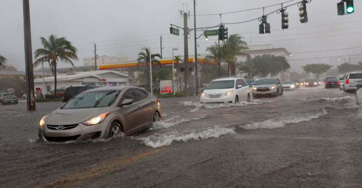
Localized Flash Flooding Possible Across the I-10 Corridor This Week
The northern stretch of Florida, especially along the I-10 corridor from Pensacola to Jacksonville, is one of the regions where flash flooding develops most often after heavy rains. Low-lying areas, rural roads, and sections surrounded by dense forests or wetlands can accumulate water quickly. When soils are already wet, even a few hours of additional rainfall may overwhelm drainage systems.
Travelers using I-10 or nearby highways should monitor updates from the Florida Department of Transportation, which provides real-time road condition reports and closure notices. Flooding on interstates and local roads can appear suddenly, sometimes after travelers have already begun their route. Motorists are strongly advised to avoid driving through standing water, as road depths can be deceptive and dangerous.
Hotels and roadside accommodations in northern Florida often have storm safety protocols in place, including guidance on alternate routes if access roads become impassable. Visitors can also sign up for county-level emergency alerts through official government websites to receive real-time notifications specific to their location.
Isolated to Scattered Showers and Thunderstorms Expected Statewide
Florida’s summer pattern of daily storms remains one of the state’s most predictable weather features. Clear mornings often give way to clouds by midday, followed by short but intense afternoon downpours. These storms can produce frequent lightning, which is a serious hazard in Florida—one of the lightning capitals of the United States.
Travelers visiting beaches, theme parks, and outdoor attractions should have a plan to quickly move indoors when skies begin to darken. Most attractions in Central Florida, including those in Orlando and Tampa, are well-accustomed to afternoon storms and provide shelters or alternative indoor activities when weather disrupts plans.
Mobile weather apps with radar features are valuable tools for monitoring rapidly developing storms. The National Weather Service also issues short-term advisories when dangerous conditions, such as severe thunderstorms or lightning, are expected. For visitors along the coast, an added consideration is the potential for stronger rip currents, which often intensify following storm activity.
Rainfall Above Normal Expected in the Coming Weeks
The state’s wet season, which generally runs from late spring through early fall, often brings periods of higher-than-average rainfall. When moisture streams in from both the Gulf of Mexico and the Atlantic Ocean, Florida experiences widespread soggy conditions. This pattern creates an environment where already waterlogged areas can struggle to drain between storms.
Local water management districts routinely monitor canals, levees, and retention ponds during these times, adjusting levels to reduce flood risks. Visitors may notice heavy equipment moving water in residential areas or along highways—these are part of routine flood-control operations that keep Florida’s infrastructure functioning during extended wet spells.
For travelers, the most practical adjustment is preparation. Waterproof clothing, quick-dry shoes, and protective covers for electronics can make daily outings more comfortable. Many attractions now provide rainy-day passes or flexible rescheduling options, ensuring visitors can still enjoy their trip even if storms alter the timing of activities.
Tropical Disturbances May Boost Rainfall and Flood Risk
Even when hurricanes are not forecast to make direct landfall, tropical disturbances in the Gulf or Atlantic often influence Florida’s weather. These systems act as moisture pipelines, increasing rainfall across the peninsula and sometimes producing flooding far from the coast. In some cases, tropical waves or depressions can bring days of unsettled weather without reaching hurricane strength.
Florida’s coastal communities have well-practiced emergency plans for these scenarios. Local officials encourage travelers to know the location of their lodging, understand evacuation routes, and monitor National Hurricane Center advisories during their stay. Even inland areas can experience effects, such as prolonged rain bands and gusty winds, when these systems pass nearby.
Visitors are encouraged to build flexibility into travel plans during the wet season. Morning hours are generally more favorable for outdoor activities, while afternoons are better reserved for indoor attractions or rest. Hotels and tour operators can provide location-specific advice, and staying in contact with local hosts or concierges is often the quickest way to understand how conditions may affect daily travel.
Dear Reader: This page may contain affiliate links which may earn a commission if you click through and make a purchase. Our independent journalism is not influenced by any advertiser or commercial initiative unless it is clearly marked as sponsored content. As travel products change, please be sure to reconfirm all details and stay up to date with current events to ensure a safe and successful trip.