Texas drivers face unique challenges when high winds sweep across the Lone Star State. These powerful gusts can transform a routine drive into a white-knuckle experience, especially on the state’s vast open highways. Understanding wind warnings in different regions of Texas isn’t just about comfort – it’s about staying safe when Mother Nature flexes her muscles.
1. Abilene Straight-Line Wind Event
When straight-line winds barrel through Abilene, they pack a punch that can push vehicles sideways without warning. These concentrated air masses move horizontally, reaching speeds of 60-80 mph across the flat terrain.
Drivers of high-profile vehicles like trucks and RVs face the greatest risk, as these winds can literally tip them over on highways like I-20. Local weather services typically issue warnings 12-24 hours before these events.
The most dangerous stretch runs from Buffalo Gap Road to Highway 351, where wind tunnels form between buildings and geographic features, creating invisible force zones that catch many drivers by surprise.
2. Houston Derecho
A Houston derecho brings widespread destruction with its bow-shaped line of thunderstorms and sustained winds exceeding 58 mph. Unlike typical Gulf Coast storms, these systems can maintain intensity for hundreds of miles, creating a moving wall of danger for drivers.
The city’s bayou-crossed landscape channels these winds unpredictably. Driving along the Sam Houston Tollway or I-610 becomes particularly hazardous as debris from the urban environment becomes airborne.
Falling trees and power lines create road obstacles with little warning. Smart Houston drivers know to pull off at sturdy structures – not under overpasses – when these distinctive green-tinged skies appear.
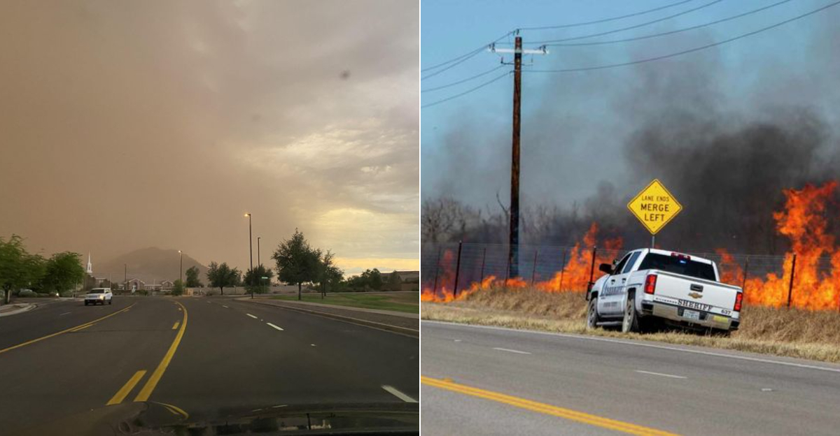
3. Wildfire Driven by High Winds – San Antonio
San Antonio’s drought-prone surroundings become perfect tinderboxes when high winds arrive. These gusts can transform small fires into racing infernos that jump highways in minutes, creating zero-visibility conditions without warning.
The northern corridors like Highway 281 and I-10 west toward Boerne face particular risk when winds exceed 40 mph. Smoke plumes can suddenly envelop roads, disorienting drivers and causing dangerous chain-reaction slowdowns.
Emergency services often close roads with minimal notice during these events. Travelers should monitor local alerts and prepare alternative routes, especially during February through April when the Hill Country’s cedar and brush become dangerously combustible.
4. DFW Wind Gusts & Driving Hazards
The Dallas-Fort Worth metroplex creates a unique wind environment where skyscrapers and open prairies meet. Strong northers can funnel between buildings, creating microburst-like conditions that arrive without the visual warning signs of storms.
Airport corridors near DFW International and Love Field experience particularly severe crosswinds. These areas become treacherous as winds push vehicles toward concrete barriers, especially along elevated portions of highways 114, 183, and 161.
Suburban drivers face flying debris from construction sites that dot the rapidly growing region. Local forecasters track these systems using “wind advisory” designations when sustained speeds reach 25-35 mph with higher gusts.
5. Amarillo Dust Storm & High Wind Warning
The infamous Amarillo dust storms transform day into night within minutes. These haboobs sweep across the Panhandle’s agricultural lands, lifting topsoil into towering brown walls that can reach heights of 1,000 feet or more.
Visibility on I-40 and Highway 287 can drop from miles to mere feet instantly. The fine particulate matter infiltrates vehicle air systems and creates dangerous respiratory conditions for those with asthma or other conditions.
Experienced Panhandle drivers recognize the telltale copper-colored horizon and pull completely off roadways before the main dust front arrives. These events typically occur between January and April when winter wheat fields lie fallow and exposed.
6. Dallas–Fort Worth Severe Storms
When severe thunderstorms collide with the Metroplex’s concrete jungle, they create wind patterns unlike anywhere else in Texas. Microbursts – intense downdrafts that hit like invisible hammers – frequently occur along the I-635 corridor and can flip vehicles without warning.
The region’s sprawling suburbs mean construction materials become deadly projectiles during these events. Meteorologists note that the “DFW Connector” interchange and other major highway intersections create unusual turbulence patterns that can amplify already dangerous winds.
Flash flooding often accompanies these wind events, creating a dual hazard for drivers. The metropolitan area’s emergency management system uses specialized highway messaging systems that provide real-time wind speed warnings at key overpasses and bridges.
7. Panhandle Blizzard & Wind Event
The Texas Panhandle’s winter blizzards combine snow with sustained winds that regularly exceed 50 mph. These systems create ground blizzards where even minimal snowfall becomes disorienting white-out conditions.
Highway 287 between Amarillo and Childress becomes particularly dangerous as the flat terrain offers no wind breaks. The region’s cattle industry means large semi-trucks often jackknife during these events, creating highway blockages that strand motorists in life-threatening cold.
Unlike northern states, Texas highways have fewer snow fences and wind barriers. Local ranchers know to watch for “blue northers” – rapidly moving cold fronts that can drop temperatures 30-40 degrees in an hour while simultaneously bringing dangerous crosswinds to east-west roadways.
Dear Reader: This page may contain affiliate links which may earn a commission if you click through and make a purchase. Our independent journalism is not influenced by any advertiser or commercial initiative unless it is clearly marked as sponsored content. As travel products change, please be sure to reconfirm all details and stay up to date with current events to ensure a safe and successful trip.