I chase quiet trails where my boots find more grouse tracks than footprints. Colorado still holds pockets of calm if you know where to look and plan with care. I pulled these routes from local tips, ranger chats, and recent reports. If you want solitude with honest effort and real rewards, this list will keep you smiling and safe.
1. Mill-Castle Trail to Storm Pass
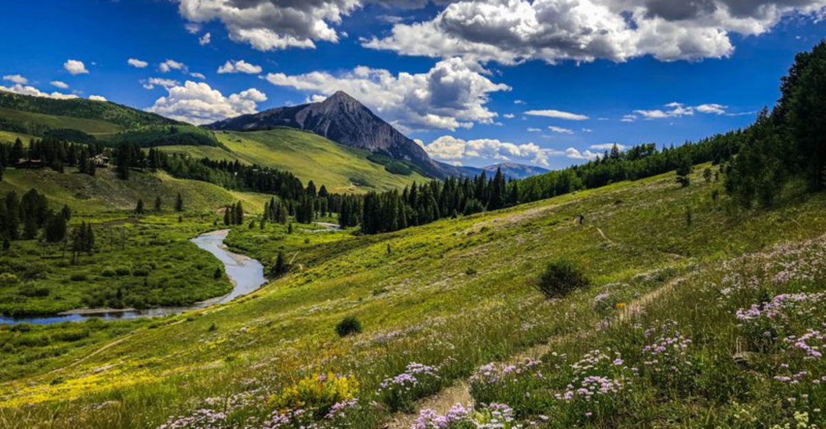
I first heard about Mill-Castle and Storm Pass from a friend who loves the Gunnison and Crested Butte area. The trail rolls through an aspen valley, then climbs toward the pass with tilted rock walls guarding the way. I carry a paper map and a GPX file because junctions can sneak up fast and turnoffs feel quiet.
The best view sits just beyond the pass, where volcanic spires frame distant ridgelines. I plan a long day, pack layers for wind, and watch the sky because storms build fast in Colorado. Water flows early season, but I treat everything. I keep my pace steady on the descent because ball-bearing gravel hides on steeper sections.
Wildlife signs often show in the meadows, so I give space and stay alert. In fall, aspen color brings a hush to the valley and the trail feels like a secret corridor. It is remote and feels committed, which I like when I want focus and room to think.
2. Sand Creek Lakes, Sangre de Cristo Range
I reach Sand Creek Lakes after a stout climb that clears the mind and replaces noise with wind. The trail rises through forest and opens to two alpine bowls wrapped by peaks that rarely draw big crowds. Access often needs rough road driving, so I check recent reports and weather before I commit.
I start early, carry extra water treatment, and stash a warm layer for the shore. The lakes reflect clouds that drift north across Colorado, and I sit long enough to let the view settle. I follow Leave No Trace, keep to established paths near the shore, and skip shortcuts that scar tundra.
Afternoon storms build fast here, so I tag the lakes and drop before the rumbles arrive. In late season, I watch for ice on shaded sections and slick roots. The solitude pays back every step and makes lunch taste better. When I leave, I move slow and look back because the second lake glows differently once the light swings.
3. Pollock Bench and Rattlesnake Arches, McInnis Canyons
Out in western Colorado, the Pollock Bench network feels quiet and raw. I follow rolling singletrack across slickrock benches, then contour through canyons lined with red sandstone. One spur links toward Rattlesnake Arches, a rare treat that sees fewer visitors than many desert hotspots.
Water runs scarce, so I carry what I need and start when the air feels cool. The trail offers open views of mesas and a sky that stretches far. I step carefully on cryptobiotic soil and stay on durable rock and sand. Spring and fall feel friendly here, while summer heat asks for discipline.
I keep an eye on cairns and check that I hold the proper line around drainages. The arches surprise me every time because each angle changes the shape. I leave no crumbs of my day and pack out every wrapper, happy I gave this landscape the pace it deserves.
4. Falls Creek Loop near Durango
North of Durango, Falls Creek feels like a secret that locals share with a smile. I follow a loop that weaves through meadows, aspen groves, and a soft forest that keeps the air cool. The route varies in length based on turn choices, so I plan my cutoff before I start and track time.
I move quiet because deer step out near the creek and birds chatter in the willows. The trail sits away from busy corridors, so I gain long stretches with nobody around. I like this loop on shoulder seasons when the ground holds some moisture and dust stays down.
I bring a light rain shell and a hat for sun, since open patches surprise me. Trail signs sit at key junctions, yet I still carry a map to keep honest. Colorado’s southwest holds many gems and this one shines on low-key days. I finish with calm legs and plan a return when leaves start to turn.
5. Tunnel Drive Trail, Cañon City
Tunnel Drive gives a short, sweet walk with plenty to look at. The path traces an old redwood irrigation canal and passes through hand-cut tunnels that face the Arkansas River. I start early and watch the light hit the canyon walls while trains roll below toward the Royal Gorge Route.
The grade feels easy, so I bring family and friends who want a relaxed day. I step aside at narrow points and let runners pass with a nod. Interpretive signs share local history that brings the cliffs to life. The trail stays open and straightforward, yet I wear sturdy shoes because gravel collects near the edges.
When raptors ride thermals over the river, I stop and scan for color bands. This route works year round with smart timing, and winter sun brings crisp views across Colorado’s canyon country. I leave grateful for a path that mixes scenery with story without crowd stress.
6. Greyrock Mountain, Poudre Canyon
Greyrock climbs fast from the Poudre Canyon and rewards patience. I choose either the Meadows route for a steady grade or the more direct ascent, then link a loop. The summit block offers fun route finding over granite slabs with big views of Roosevelt National Forest.
I start early to dodge heat and afternoon storms that build quick in Colorado. Water runs in spots but I still bring plenty and a filter for backup. Footing shifts from pine needles to rock and back again, so I place each step with care. On clear days I spot the river’s silver line cutting the canyon.
I keep breaks short to reach the top before clouds grow. The descent asks for knees that still have juice, so I save something for the final switchbacks. I sign the register, thank the wind for keeping bugs down, and head for the trailhead with a quiet grin.
7. Hidden Connectors, West Elk and Gunnison Region
Locals talk about faint connectors that branch from main trails across the West Elk Wilderness near Gunnison and Crested Butte. I never assume access or status, so I stop at ranger offices and ask about current guidance. Some paths started as cattle tracks or old roads and still link basins if you know where to look.
I carry a map and compass and confirm my route on known junctions before I step onto any use path. These lines open quiet pockets with aspen stands, dark timber, and soft meadows. I log coordinates and stay flexible because downed trees can hide segments.
I avoid cutting switchbacks and turn around if I hit private land signs. Storm cycles shift fast here in Colorado, so I track weather windows and plan exit points. I travel light but add a small repair kit for boots and poles. When I return, I leave notes with rangers so the next visitor walks in with good info.
8. Mount McConnel, Cache la Poudre
Mount McConnel sits close to Fort Collins but keeps a mellow vibe. The loop rises through fir and pine, then tops out with views over the Cache la Poudre country. I like it when I want a shorter outing with a real summit feel. The grade holds steady and the switchbacks keep footing sane.
I start early to beat afternoon weather and to hear birds before traffic noise picks up. Signage helps, yet I bookmark a map for junctions with the Kreutzer loop. I pack a light puffy even on warm days because wind can kiss the top. In shoulder seasons, patches of ice linger in shade, so microspikes ride in my pack.
This trail offers a clean read of the foothills as they lean toward the high country of Colorado. I finish with that nice mix of effort spent and time left for a snack by the river.
9. Quiet Rims of Black Canyon and Curecanti
Most people stop at signed overlooks in Black Canyon of the Gunnison, but I ask rangers about lesser rim paths and short connectors. These routes hug the edge with safe setbacks and give fresh angles into the dark walls. Some descents require permits, skill, and current conditions, so I stick to what matches my experience.
I mark my turnaround time and keep a strict buffer for the hike back. The Curecanti side holds mellow walks with broad views across the reservoir and layered mesas. I carry sturdy shoes and watch for loose pebbles on slanted rock.
Raptors ride the winds above the gorge, and I pause to scan while I sip water. Weather shifts quickly along the rim in Colorado, so I bring a shell and warm gloves. I step wide of fragile plants near the cliff tops. I leave with a healthy respect for the depths and a phone full of shadow and light.
10. Use Trails in the Sangres: Crestone and Westcliffe
In the southern Sangre de Cristo, locals mention small use paths that split from mapped routes near Crestone and Westcliffe. I treat these with care and verify access, since some cross private lands and conditions change. I ask at ranger stations and check recent trip reports before I leave the pavement.
These lines slip into basins, hidden lakes, and ridges that sit well away from busy trailheads. I keep my navigation sharp and avoid shortcuts that cut fragile slopes. If a path fades, I backtrack rather than guess. Afternoon clouds build fast in Colorado, so I plan climbs early and set safe turnaround times.
I carry a headlamp, extra food, and layers even on short outings. Elk sign shows often and I give wide space and quiet respect. When I finish, I note what I learned and share clear, legal options without broadcasting sensitive locations.
Dear Reader: This page may contain affiliate links which may earn a commission if you click through and make a purchase. Our independent journalism is not influenced by any advertiser or commercial initiative unless it is clearly marked as sponsored content. As travel products change, please be sure to reconfirm all details and stay up to date with current events to ensure a safe and successful trip.