I went looking for a quiet corner of South Carolina and found two places that rewrite how we talk about memory and time. Springs Recreational Park near Inman whispers from behind the trees, while Poinsett Bridge stands in the open like a stone page from an old travel diary.
Together they show how history lingers when caretakers leave and nature steps in. If you’re curious, careful, and patient, these sites reward you with stories you won’t forget.
Springs Recreational Park: The Forgotten Pool
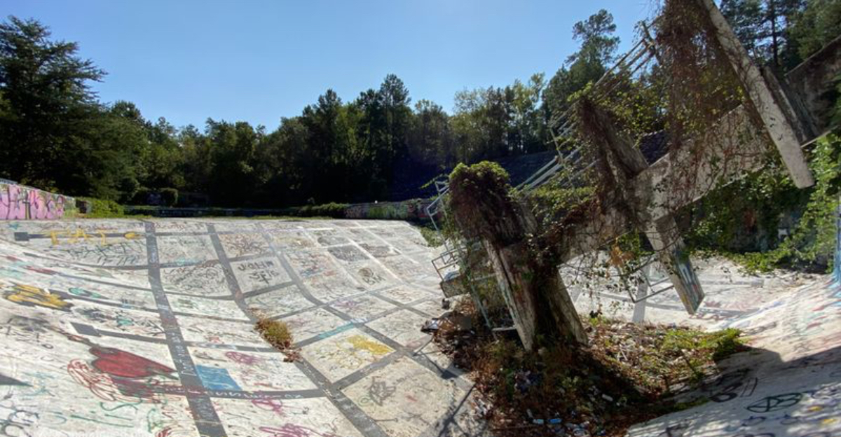
Springs Recreational Park sits on the edge of Inman in Spartanburg County, where a textile company built a leisure haven in the 1920s for its community. I walked along the perimeter and saw the silent centerpiece, a once Olympic-style pool now filled with leaves and shadow. Rust stains the railings, and the bathhouse walls show soft colors that time washed thin.
Birds nest in the rafters, and the breeze carries a low hush that settles on the cracked deck. The site is not maintained, and fencing stands in places, so I kept a respectful distance and took notes from outside. Local histories and photo surveys document the site’s decline; treat crowd-sourced ‘ruin’ features as anecdotal and confirm current access locally. I agree, but not because of scares. The beauty comes from context, from a working era that built recreation to match the pace of mills and shifts.
You won’t find guides or posted hours here, and you may face restricted access. If you go, check local regulations and ask permission where required. Bring sturdy shoes, arrive in daylight, and leave the scene untouched. I met no crowds, just a faint echo of community picnics and summer laughter that South Carolina air seems to hold.
Poinsett Bridge: Stone Arch Over Little Gap Creek
I drove north into Greenville County to see Poinsett Bridge, the oldest bridge in South Carolina. The Gothic arch lifts over Little Gap Creek with clean stonework that still looks precise. Trails lead in gently, and information boards describe the early road that once crossed the Blue Ridge. The bridge sits within Poinsett Bridge Heritage Preserve in Greenville County, which is actively managed and open during posted hours.
I listened to the water move under the arch and traced the cut lines in the rock with my eyes. The craftsmanship holds up after centuries, and you can view the span from several angles. People trade ghost stories about lights and voices at night. I did not find evidence for that, and local accounts remain anecdotal. I visited during daytime and found a relaxed pace and open sightlines.
Park rules appear on posted signs, and the preserve looks actively managed. Check the county/manager page for current hours, parking, and trail advisories before you go. It’s an easy stop if you want history and a short walk. Wear good shoes, respect the creek, and keep to the trail. The bridge lies within a wider green corridor, so birds show up often. If you want a quiet landmark with clear backstory, this South Carolina icon serves it without fuss.
Textile Roots: Springs Industries’ Social Landscape
Springs Recreational Park reflects a broader Upstate mill-village pattern in which textile companies funded pools, ballfields, and parks for workers. I dug through local histories and found that these amenities supported community life around mills. Families gathered on weekends, and the park gave structure to time off. When industries shifted and operations moved, the leisure spaces lost sponsors.
That change explains why the pool and pavilions faded. The story matches patterns across the Piedmont, where manufacturing once shaped towns block by block. Walking the edges of the property today, I could still map the social geometry. The pool sat central, with paths linking to shade and seating. The park told visitors where to linger and where to cool down after hot seasons.
You won’t find printed brochures on site, so you need to arrive with context. County archives and regional museums provide the best references if you want deeper study. I keep notes and compare photos so I don’t misread what I see. This kind of groundwork helps me travel better in South Carolina, because it connects small landmarks to larger forces. It also reminds me that recreation leaves footprints long after crowds go home.
Nature’s Quiet Reclaim: Plants, Pollen, and Patina
At Springs Recreational Park, nature works slowly and steadily. Vines climb rails, and lichens paint small constellations on concrete. Pine needles collect on every flat surface, and the pool basin gathers rainwater that evaporates into damp rings. I watched a line of ants cross a hairline crack while a hawk circled high above. The scene felt calm, not spooky.
It read like a patient reset, where plants reclaim room that people once shaped to suit a schedule. Do not cross fences or enter structures. Ruins conceal drop-offs and unstable surfaces; observe from lawful, stable ground only. Leaves can hide tripping hazards, and old timbers may not hold weight. Good footwear matters because slick patches appear after showers. I also keep noise low so birds and small mammals continue their routines.
If you visit, pack out everything and leave the setting cleaner than you found it. The color palette of this corner shifts with seasons, from deep greens to warm browns. The textures reward close looking. This kind of field time adds a softer layer to a South Carolina itinerary. It reminds me to slow down and read surfaces, not just signs.
Reading the Pool: Lines, Ladders, and Echoes
The pool at Springs Recreational Park tells a clear story without words. Lane lines linger as faint bands of color, and the ladder mounts anchor into concrete like punctuation marks. I paced the edge and counted the turns where swimmers once pushed off for another lap. The geometry still guides how your eyes move. You can spot expansion joints, drains, and the outline of a shallow shelf. These details help date the build and reveal maintenance choices from a different era.
Historic aerials and on-site remnants (lane lines, drain placements, expansion joints) provide the clearest evidence of former layout. The view sits quiet, and the setting feels off the main path. I never cross barriers or ignore posted notices, and I keep to public vantage points. The best time for photos comes when the sun sits low and shadows stretch across the deck.
Check weather so the ground stays safe underfoot. Bring water and a small light if trees block the sun. The site reads like a dry textbook turned into a walk, which makes it a rare kind of classroom in South Carolina. Every corner holds a trace of life that once gathered here.
Responsible Access: Safety and Etiquette
I plan these visits with caution. Abandoned places can hide weak floors, open pits, or sharp metal. I arrive during daylight, bring a friend when possible, and keep a charged phone and a basic first aid kit. I wear sturdy shoes and long sleeves to guard against thorns. I also check county rules, look for fencing, and follow posted signs. Legal reminder: Trespass in South Carolina can carry fines and criminal penalties. When in doubt, leave and seek written permission.
If a gate says keep out, I respect it and move on. No photo or story justifies unsafe or illegal steps. Local residents care about these places, even if they no longer operate as attractions. I keep voices low and avoid blocking driveways or narrow roads. I never remove materials or disturb wildlife.
If I meet neighbors, I greet them and explain what I’m documenting. That simple exchange builds trust. I also share location details carefully to avoid crowding fragile areas. These habits make visits smoother across South Carolina. They also protect the sites so future visitors can see the same details I saw.
Context Trail: Linking Bridge, Mills, and Backroads
Build a legal, low-impact loop: start at Poinsett Bridge Heritage Preserve, then use public roads to view (not enter) extant mill-village streetscapes and churches. Old road traces, farmsteads, and mill histories knit through the countryside. I like to connect stops to build a fuller day. Start at the heritage preserve, read the plaque, and step down to the creek for a look at the stonework. Then drive secondary roads that pass former mill villages. You’ll see brick shells, company houses, and churches that still hold weekly services.
Each site adds a layer to the story of work, travel, and rest in the upstate region. Official sources describe the bridge dimensions and the 1820 build date. That gives you a solid anchor for timelines. I pair that with county historical society notes and state preserve pages to verify current access and trail conditions.
Navigation apps help, but bring a paper map as backup where cell coverage drops. I stop for local food near the route and keep receipts for my notes. This calm loop shows how South Carolina history sits within easy drives and short walks. By the end, the arch, the pool, and the roadside markers start to speak to one another.
When Legends Meet Evidence: Night Myths vs Daylight Facts
Both the bridge and the old park carry stories that lean into chills. I’ve heard accounts of lights near the arch and footsteps near the pool. These tales help build local lore, but they do not come with clear proof. Daytime visits tell a different story. You see stone joints, plant succession, and civic signs that explain management. The contrast matters because it guides how to plan.
Facts make trips smoother and safer, while legends add local color if you hold them lightly. I keep an open mind and a careful eye. I record sounds, take photos, and compare notes with published sources. If new evidence emerges, I update my understanding. In the meantime, I treat both sites with care. The bridge is open within preserve rules. The former Springs park area has no public facilities and includes restricted parcels; plan for viewpoints from public locations only.
The park sits largely abandoned and may restrict access. I plan responsibly and never force entry. That balance gives me a calm, thoughtful South Carolina route where curiosity stays grounded and the past remains readable in the present light.
Dear Reader: This page may contain affiliate links which may earn a commission if you click through and make a purchase. Our independent journalism is not influenced by any advertiser or commercial initiative unless it is clearly marked as sponsored content. As travel products change, please be sure to reconfirm all details and stay up to date with current events to ensure a safe and successful trip.