Oregon’s waterfalls are some of the most stunning natural attractions in the Pacific Northwest, drawing millions of visitors each year. Unfortunately, the desire for that perfect photo or a more adventurous experience leads many tourists to wander off designated trails and onto dangerous, illegal paths.
These unauthorized routes not only put hikers at serious risk but also damage fragile ecosystems and contribute to costly erosion problems that affect everyone.
1. Social Trails to the Plunge Pool
Faint paths carved by previous hikers often tempt visitors to leave the main viewing platform and scramble down toward the waterfall’s base. These routes might look harmless at first glance, but they’re incredibly unstable and prone to sudden collapses.
Park officials frequently post closure signs along these so-called social trails because of the serious slip hazards they present. Heavy foot traffic accelerates erosion, making the hillside even more dangerous over time.
What seems like a quick detour can quickly turn into a life-threatening situation when the ground gives way beneath your feet.
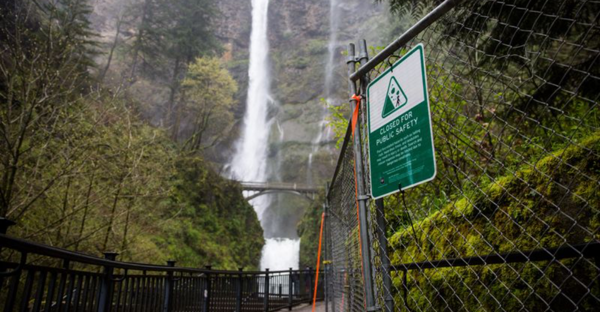
2. Jumping the Fence for the Perfect Selfie
Chain-link fences and wooden barricades exist for a reason, yet some visitors see them as minor obstacles standing between them and Instagram gold. Climbing over barriers placed due to fire damage or unstable cliffs has become alarmingly common at popular waterfall sites.
The goal is usually to capture a dramatic photograph that hides all the safety infrastructure, creating the illusion of untouched wilderness. Unfortunately, this risky behavior often results in injuries, rescues, and even fatalities.
That perfect selfie isn’t worth risking your life or facing hefty fines from park rangers.
3. Bypassing the Larch Mountain Trail Closure
Multnomah Falls is Oregon’s most visited natural recreation site, but not all sections of the surrounding trails are always open to the public. Many adventurous hikers ignore posted warnings and venture beyond the Benson Bridge to explore damaged or unmaintained upper trail sections.
These closed areas often feature breathtaking views from the very top of the falls, which makes them irresistible to some visitors. However, the trails may have severe damage from rockslides, washouts, or fire impacts that make them genuinely hazardous.
Respecting closure signs protects both your safety and the restoration work happening in these areas.
4. Creating a Path to the Waterfall’s Edge
Official viewpoints are carefully positioned to offer stunning views while keeping visitors safe from sheer drops and crumbling rock faces. Yet some tourists bypass these designated spots entirely, determined to stand right at the waterfall’s edge where water begins its dramatic plunge.
At locations like Salt Creek Falls, this means walking onto highly unstable ground that can collapse without warning. The rock and soil at cliff edges are constantly weathered by moisture and freeze-thaw cycles, making them unpredictable.
One wrong step could send you tumbling over the edge along with the cascading water.
5. Following the Creek Upstream or Downstream
Wandering along the watercourse itself seems like a natural way to explore, especially in scenic canyons where the sound of rushing water beckons you forward. Many visitors leave designated trails to walk upstream or downstream, hoping to discover hidden waterfalls or secluded pools.
Places like the now-closed Oneonta Gorge became famous partly because tourists created their own routes through the creek. These unauthorized paths damage riparian habitats and put hikers at risk from flash floods and slippery rocks.
Staying on official trails ensures you see nature’s beauty without destroying it in the process.
6. Ignoring Post-Fire Closure Signs
The devastating wildfires that swept through the Columbia River Gorge left behind more than just charred landscapes, they created ongoing hazards that persist for years. Tourists frequently ignore bright warning signs that alert them to dangers like falling trees, commonly called widowmakers, and unstable rockslides.
Fire-damaged trees can topple without warning, especially during windy conditions or heavy rain. The ground itself becomes less stable as root systems decay, increasing the risk of landslides along trails.
These closure signs aren’t suggestions; they’re critical warnings meant to keep you alive and uninjured during your visit.
7. The Shortcut Through Sensitive Habitat
Switchbacks exist to make steep terrain safely navigable, but impatient hikers often cut straight through the curves to save a few minutes. This shortcutting behavior quickly tramples fragile vegetation and creates visible new dirt paths that encourage others to follow the same destructive route.
Mosses, ferns, and delicate wildflowers that took decades to establish can be destroyed in a single season of heavy foot traffic. The resulting erosion channels rainwater in unnatural ways, causing further environmental damage.
Those extra few minutes you save aren’t worth the lasting ecological harm you leave behind for future generations.
8. Descending to the Base of Restricted Falls
Some of Oregon’s most beautiful waterfalls, like Toketee Falls, only offer official upper viewing areas for very good safety reasons. Despite clear restrictions, determined tourists use ropes or scramble down incredibly steep, unmaintained routes to reach forbidden lower observation points or pools.
These user-created trails are extremely dangerous, featuring loose rock, exposed roots, and near-vertical drops that require technical climbing skills. Rescuing injured hikers from these locations puts first responders at serious risk and costs taxpayers thousands of dollars.
Enjoying the view from the designated platform is far better than becoming a rescue statistic or facing criminal charges.
9. Scaling the Rocks Around Barrier Fences
Barrier fences exist for good reasons, they mark dangerous zones and protect sensitive areas from foot traffic. Yet some visitors see these wooden or metal barriers as minor obstacles rather than serious warnings. Climbers scramble over rocks adjacent to fences, thinking they’ve found a clever workaround to get closer views.
Park rangers report that this behavior has increased dramatically with social media popularity. People want that jaw-dropping photo nobody else has captured. The problem? These rocky detours often lead to unstable ground where landslides happen frequently.
Erosion worsens each time someone steps off the trail, and rescue teams risk their lives retrieving injured trespassers. Respecting barriers keeps everyone safer and preserves the landscape for future generations to enjoy responsibly.
10. Using GPS Coordinates Shared on Travel Blogs
Travel bloggers sometimes share exact GPS coordinates to hidden waterfall viewpoints, not realizing these spots might be off-limits or ecologically fragile. Enthusiastic readers plug these numbers into their phones and follow digital breadcrumbs straight to restricted areas. What seems like helpful insider information actually encourages rule-breaking on a massive scale.
Many of these coordinates lead to paths created by previous trespassers rather than official trails maintained by park services. Vegetation gets trampled, wildlife habitats suffer disruption, and soil erosion accelerates with each new visitor.
Before following any online directions, check official park websites or contact ranger stations. Legitimate viewpoints don’t need secret coordinates, they’re clearly marked and designed to handle visitor traffic safely while protecting the surrounding environment from unnecessary harm.
Dear Reader: This page may contain affiliate links which may earn a commission if you click through and make a purchase. Our independent journalism is not influenced by any advertiser or commercial initiative unless it is clearly marked as sponsored content. As travel products change, please be sure to reconfirm all details and stay up to date with current events to ensure a safe and successful trip.