When Lake Powell receded during recent drought years, Arizona began whispering the name of a place many thought gone for good. Glen Canyon, once drowned by the reservoir behind Glen Canyon Dam, has been peeking back into daylight.
Cathedrals of sandstone, alcoves, and ghostly inscriptions have reappeared like a mirage made real. If you want to feel time shift under your feet, this is the Arizona story to chase.
While most travelers reach it from Page, Arizona, it’s worth noting that Glen Canyon and its submerged Cathedral in the Desert span both Arizona and Utah. The reservoir and its canyons cross the state line, linking two landscapes in one shifting story.
Cathedral in the Desert Returns
Low reservoir levels have periodically revealed the soaring chamber locals call Cathedral in the Desert, a Glen Canyon alcove once submerged by Lake Powell. When water retreats, its high vault and pour-over canyon become visible, creating a natural sanctuary that travelers photograph from boats or by canyoneering with proper permits where required. This reveal is intermittent, changing with seasonal inflows and basin-wide climate trends that the U.S. Bureau of Reclamation reports in monthly updates.
Visitors approaching from the Arizona side should plan for backhauls or guided boat transport, since access depends on launch conditions near Page. Sound carries softly inside the alcove, where dripping water can echo against Navajo sandstone. The return of the cathedral is both celebration and cautionary tale, a reminder of the Southwest’s limited water.
Check recent satellite imagery or ramp-status bulletins before attempting any visit, since safe landings vary. The experience feels intimate, even when others arrive, because the canyon’s soundscape reduces chatter to murmurs. Photographers favor indirect light that washes the walls in amber. Arizona’s sky, vast and articulate, frames the reemergence like a stage curtain parting on a once-buried set.
Echoes at Forgotten Ramps
Boat ramps that once bustled have fallen silent during extended low water, leaving long concrete tongues that now end high and dry. On Arizona’s side near Wahweap, the geometry of access infrastructure stands in contrast to the organic lines of surrounding sandstone. The National Park Service updates ramp status frequently, reflecting how quickly conditions shift.
Walking along abandoned segments, you can sense former movement in striping, anchor points, and tire scuffs that lead nowhere. It is not dereliction so much as a pause, a record of how recreation adapts to climate signals. The surrounding cliffs absorb sound, creating an acoustic hush that makes footsteps seem loud. Signage asks visitors to stay off closed sections, an important safety and conservation measure.
Light pools under cantilevered shade structures, sketching rectilinear shadows across desert varnish. Arizona’s sun bakes color from painted surfaces, leaving chalky blues and faded reds as quiet accents. These places teach humility. They show how engineered certainty can stall while the canyon continues its slow, sculptural work. Here, photographs favor lines and negative space, the poetry of stillness stitched into concrete and stone.
The Drowned River’s Footprint
Before inundation, the Colorado River meandered through Glen Canyon with terraces, side canyons, and alcoves etched into Arizona’s canyon country. As levels dropped, the old river footprint became legible again in mudflats, stranded driftwood, and newly exposed beaches. Researchers and land managers note rapid changes as silt deposits consolidate or slump, so footprints and access lines can shift month to month.
The reappearance is not uniform, since upstream flows and dam releases rearrange shorelines across the reservoir’s arms. For travelers, reading the landscape feels like decoding a palimpsest, where each stratum tells a layer of the canyon’s pre-dam story. It is essential to watch for unstable sediment and to respect closures when restoration crews or archaeologists are at work.
Arizona’s reach of the reservoir near Wahweap and Antelope Point offers an evolving introduction to this transformation. Standing at the margin, you can see bathtub rings trace prior high water, a stark ledger of hydrology. The effect is contemplative, a lesson in time written in chalk and clay. Every step carries the sense of a map being redrawn, line by line. Nature, patient and persistent, keeps editing the page.
Archaeology at the Water’s Edge
Lower lake levels have exposed sites that archaeologists monitor with care, including masonry remnants, lithic scatters, and rock art panels. Federal and tribal teams coordinate to document and protect them under cultural resource laws, and visitors are required to leave artifacts undisturbed. The exact locations are often not publicized to deter looting, but general updates appear in land management reports and academic conferences.
If you encounter fencing, signs, or active crews, keep a respectful distance. The story stretches far beyond the dam era, back to ancestral peoples who moved through Glen Canyon’s alcoves and benches. Their presence is felt in pecked images, hearth stains, and quiet architectural clues that only fully emerge when water retreats. Arizona’s cultural landscape is deep, and it becomes more visible with each dry season.
Ethical travel means admiring patterns, not collecting them. Binoculars and a good guidebook can enrich the experience without crossing boundaries. The feeling of witnessing a reappearing archive is powerful. It asks for patience, humility, and care, so that future visitors can still meet these traces where sandstone and silence keep the record.
The Cathedral’s Acoustic Chamber
Sound behaves differently in Glen Canyon’s alcoves, and the effect becomes remarkable as once-drowned chambers dry out. A whispered phrase may travel across the bowl and return softened, while small drips turn into rhythmic metronomes along sculpted walls. Field recordists have documented these patterns with sensitive microphones, noting how humidity and water level alter resonance.
You do not need equipment to notice the phenomenon. Simply stand still and listen. The air cools in shade, and the canyon amplifies subtle details of wind and footfall. On quiet days, it feels like a private concert hall curated by geology. Arizona’s big skies fall silent outside, then narrow to a polished echo as you step in. Respect others by keeping voices low, since the acoustics can stretch a whisper.
The absence of engine noise adds to the sensation of time pausing. Photographs here work best when they include the interplay of shadow and curved stone. If water returns, the acoustics shift again, replacing echoes with watery hush. The canyon’s voice is seasonal, articulate, and unhurried, a reminder that nature conducts the score.
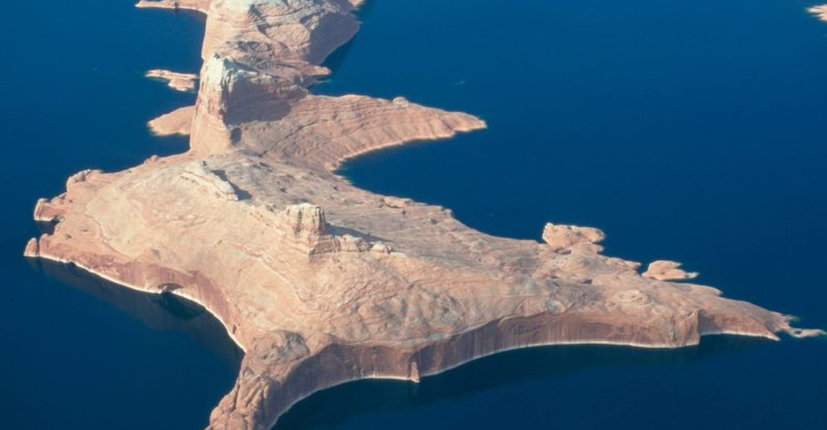
Reading the Bathtub Ring
The pale mineral stain banding Lake Powell’s walls is a visible archive of fluctuating levels. That ring, a contrast line against rust, umber, and rose-colored sandstone, maps years of hydrologic change. Scientists and journalists alike use it as a simple reference to communicate drought impacts across the Colorado River Basin. For travelers, it functions like an interpretive panel painted by evaporation.
Stand at a turnout near Page, Arizona, and trace the ring with your eyes along the striated cliffs. Each shift in tone hints at water’s comings and goings. The starkness is moving because it is exact, a ledger that requires no caption. Photographers can play with scale by placing foreground rock against faraway ringed walls. It is not a judgmental mark, simply a measurement left in plain sight.
When storms arrive, new streaks descend like vertical ink, adding texture to the story. The canyon wears its history openly. That honesty is part of the appeal of Arizona’s desert light, which refuses to hide the details and, instead, makes every seam and edge legible.
Shifting Shorelines, Moving Plans
Trip logistics in Glen Canyon have become dynamic, a direct outcome of hydrology. Launch points open or close, marinas shift services, and backhaul options change with channel depths. The National Park Service and concessionaires post current conditions, which smart travelers check the week of departure. Flexibility turns from virtue to necessity.
On Arizona itineraries, many base themselves in Page for quick response to changing ramps and guides. Extra time in the plan helps if wind or low water delays a crossing to side canyons. Maps that once felt final now require updates, so download offline layers and carry backups. Safety grows from preparation, not bravado, especially when mudflats or submerged debris complicate landings.
The reward is a quieter canyon, fewer crowds away from the main channel, and long sightlines across newly revealed benches. Arizona rewards patience with clarity. Watching the reservoir breathe in and out across seasons, you feel like a participant in a living atlas. The path forward is to travel lightly, adapt quickly, and let the canyon set the tempo.
A Timeline Written in Sandstone
The rock tells a longer story than any map, with cross-bedded Navajo sandstone preserving ancient dunes and wind directions. When the reservoir recedes, those cross-beds appear crisp along fresh exposures, a geology lesson at full scale. Interpretive materials from nearby parks explain how these layers formed under desert conditions long before the canyon incision.
Running your eyes along the inclined planes, you can see the history of an ancient erg translated into sculpture. Light enhances the pattern in morning and late afternoon, when shadows articulate each ridge. The effect is painterly, but exact to the science. Arizona’s desert geology is legible for anyone who slows down. You do not need specialized vocabulary to appreciate the forms.
Respect closures where erosion control is underway, since fragile slopes can crumble under casual footsteps. Photograph textures rather than broad vistas to bring out the fine grain. Every exposed panel feels like a new page in a book that was closed for decades. With the water lower, the canyon is lending its atlas back to the sun.
Stepping Carefully on New Ground
Freshly exposed shorelines can look inviting but behave unpredictably. Saturated sediments may appear firm, then liquefy under weight, a common hazard near receding reservoirs. The National Park Service advises staying on established paths, rock surfaces, or obviously compacted ground. Footprints in fragile areas can also accelerate erosion, altering nascent plant communities that are starting to colonize the margins.
Good footwear, trekking poles, and measured steps reduce risk. Carry a simple safety plan and tell someone your route, especially when exploring away from boat traffic. Arizona’s arid heat complicates recovery if you get stuck, so water, sun protection, and patience are essential.
The benefit of caution is access to quiet angles of the canyon that feel personal and wild. In those spaces, the return of lichen, grasses, and small shrubs writes a hopeful footnote to a complex water story. The land is relearning itself as the shoreline moves. Travel kindly and you become part of that careful restoration, a visitor who leaves a light touch where stone and silt meet sky.
Page as a Basecamp of Light
Most Arizona adventures into the reemerging Glen Canyon begin in Page, where sunrise and sunset wash buildings and buttes in soft color. The town’s services make it a practical staging point, with outfitters, marinas, and information centers offering current conditions. From here, travelers fan out to overlooks and marinas in minutes, then return to a small community that understands the rhythm of the reservoir.
Evenings bring quiet streets and a sky full of stars when clouds cooperate. For a sense of place, explore public overlooks that frame the reservoir’s changing edge, then head back to rest and plan. The beauty lies in how efficiently Page connects planning with landscape.
Arizona’s northern rim country opens in every direction, with highways carving through mesas toward the canyon labyrinth. Keep curiosity at the center of your schedule. When the lake drops, new possibilities appear. When it rises, different angles return. Either way, Page makes a steady anchor, a simple home base for a story that refuses to sit still.
Dear Reader: This page may contain affiliate links which may earn a commission if you click through and make a purchase. Our independent journalism is not influenced by any advertiser or commercial initiative unless it is clearly marked as sponsored content. As travel products change, please be sure to reconfirm all details and stay up to date with current events to ensure a safe and successful trip.