Every year, travelers head into North Carolina’s Blue Ridge and Smoky Mountains expecting easy scenic drives. What they discover instead are winding roads that test patience, focus, and respect for the landscape. Locals say the lesson comes fast, beauty and caution travel the same lane here. I went to learn why the roads feel different and came back with stories you can use on your own trip.
1. Curves that never quit
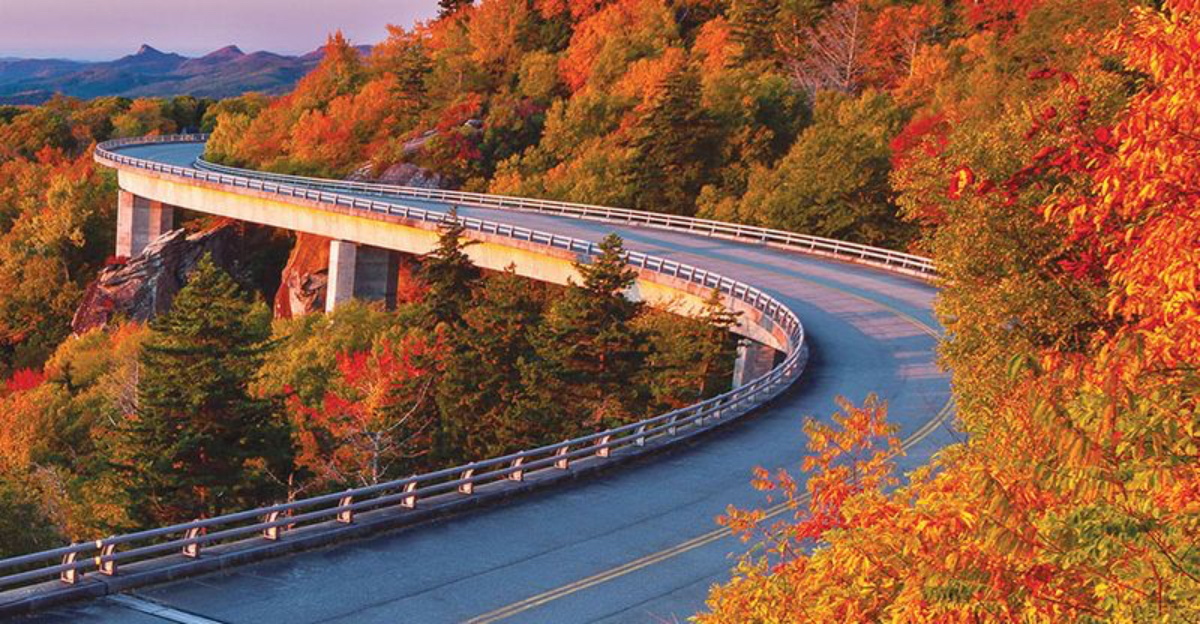
First-time visitors often underestimate how tight and frequent the turns are. Routes like the Blue Ridge Parkway or U.S. 129, better known as the Tail of the Dragon, can pack hundreds of curves into a few miles. What looks like a leisurely drive on a map feels more like a dance once you’re behind the wheel. I found that every bend demanded a plan and a light touch, especially where shade hid damp patches.
The feel of the road changes with elevation and tree cover. Pavement grips well in most segments, but fallen leaves can slick the line through a corner. Pull-offs appear often enough to reset your focus, and I used them to relax my hands and scan the next stretch. The Tail of the Dragon posts clear signage and heavy enforcement, which keeps speeds in check.
The Blue Ridge Parkway sets lower limits that reflect sightlines and wildlife crossings. Curves link together like beads, each one asking for smooth inputs rather than hard braking. If you enjoy precise driving, you will love the rhythm here. If you do not, you will still respect it by the second overlook.
2. Speed limits actually matter
Tourists quickly learn that local drivers keep to the posted speeds for a reason. The grades and switchbacks make even small misjudgments risky. Many travelers say the first descent into fog or mist teaches them to ease up and trust the signs. I kept my pace steady and left extra space, which made the drive calmer and safer.
The Tail of the Dragon runs 11 miles along U.S. 129 on the Tennessee–North Carolina border and packs 318 curves into that short distance, making it one of the most technical scenic drives in the region.
Enforcement along popular stretches stays visible and consistent. Rangers and troopers focus on behavior that endangers others, not minor deviations. Sharp drops near tunnels and overlooks can hide slower traffic and cyclists. Advisory speeds before hairpins match what your tires and view can handle. I found that following them reduced fatigue by the end of the day.
Most crashes in the region involve speed in curves or inattention. The simplest fix is to treat the sign as good information, not a suggestion. North Carolina posts frequent updates where conditions change fast, so reading the roadside helps as much as any app. Your reward for patience is clear: more time to savor each ridge and fewer surprises around the next bend.
3. Weather changes fast and often
Clear skies in Asheville can turn into heavy fog or rain an hour later. Elevation shifts bring sudden temperature drops, and cloud cover moves in like a curtain. Smart travelers pack layers and never assume visibility will stay the same from one ridge to the next. I kept a paper map and checked forecasts before each segment, since radar often lags in complex terrain.
Fog gathers most often near gaps, river valleys, and early mornings after rain. Afternoon storms pop up in warm seasons and fade by evening, leaving wet pavement in shaded corners. In fall, leaf season draws steady traffic, and that magnifies the effect of sudden showers on braking distances. Winter can bring black ice on north-facing slopes and bridges.
I watched locals flip on headlights early and tap the horn before a blind curve when fog thickened. That small habit improves your presence to others. Western North Carolina posts closure notices for slides and fallen trees through official channels and parkway status pages. Quick checks save long detours. The road always rewards those who plan for the sky to change twice before lunch.
4. Locals drive with quiet precision
Mountain residents know every blind curve and pull-off. Tourists notice how calmly locals handle steep grades and narrow lanes. The unspoken rule stays simple: stay in your lane, let faster traffic pass, and never block scenic overlooks for long. I learned to use the many turnouts and waved people by to keep the flow smooth.
Locals hold steady throttle on climbs and select lower gears on descents. They avoid tailgating and signal early before pulling into overlooks. In towns like Maggie Valley and Blowing Rock, drivers roll through with courtesy and treat crosswalks with care. You see careful spacing behind trucks and motorcycles, especially on wet pavement. The best tip I picked up was to look far through a curve and keep inputs light.
That mirrors how locals keep their vehicles balanced. Courtesy extends to parking areas where short stops keep space available. On popular weekends, patience matters as much as skill. When visitors match the local tempo, traffic feels less stressful and more enjoyable. North Carolina roads teach the value of rhythm, and the people who live there set the pace.
5. GPS is not always reliable
Signal fades quickly in mountain valleys. Visitors who rely solely on navigation apps often find themselves rerouted onto gravel roads or dead ends. Locals recommend keeping paper maps or downloading offline versions before heading into the hills. I saved routes for the Blue Ridge Parkway and Cherohala Skyway in advance and avoided last-minute surprises.
Steep slopes block satellites and cell towers, especially near deep river gorges. Some scenic byways cross county lines where coverage changes without warning. Trailhead pins can be misplaced by a mile or more, so cross-check coordinates with official sites. Overlooks and visitor centers often post route boards with distances to key junctions. I write those down, then confirm mileage markers while driving.
If a turn looks wrong, I pull into a safe turnout and reset. Rural gravel spurs may look tempting but can narrow quickly. Keeping directions handy makes the trip smoother and protects road shoulders from U-turn damage. North Carolina’s byway pages and park service alerts provide verified closures and detours. That small bit of prep lets the maps guide you, not mislead you.
6. The views demand attention but not while driving
Those sweeping overlooks are tempting, but pulling over safely is key. Many newcomers admit they nearly veered off while trying to snap photos. The lesson stays clear. The scenery will still be there when you stop. I chose overlooks with roomy pull-outs and used hazard lights only when appropriate, not while moving.
Overlooks along the Blue Ridge Parkway and U.S. 276 offer wide angles without stress. Stone walls and marked spaces keep cars organized, and posted signs point to short paths for better views. I kept cameras stowed until parked and set a quick plan for the shot. That kept my mind on the road between stops. Morning and late afternoon give softer light and calmer traffic.
Midday glare can wash out depth cues and reduce contrast in curves. A pair of polarized sunglasses helps cut reflections from wet pavement. North Carolina signed overlooks well, so you rarely need sudden decisions. Taking photos from a safe stop turns a drive into a string of moments you can enjoy without risk.
7. Brakes need breaks too
Downhill stretches can test even newer vehicles. Tourists learn to use lower gears instead of riding the brakes. Locals call it listening to the mountain, letting gravity do its work without overheating your car. I shifted early before long descents and watched engine speed rather than stabbing the pedal.
On roads like NC 226A, also known as the Diamondback, grades and hairpins come in quick sets. Engine braking keeps pads cool and preserves feel in the corners. I checked brake response after each major drop and paused at pull-offs if I sensed fade or smell. Truck ramps are rare here, so prevention matters. Keep extra space, especially behind heavier vehicles. Short stops cool components faster than creeping forward in a line.
Tires also heat up on rough pavement, so regular pressure checks help. For long trips, a pre-drive inspection pays off. In North Carolina, mountain shops know these patterns and can advise on fluids and pads that handle heat better. A smooth descent saves parts and keeps your focus on the road and view.
8. Motorcyclists share the road
North Carolina’s mountain routes attract riders from across the country. Tourists soon learn to check mirrors often and give space. The winding roads are beloved by both drivers and bikers, but mutual awareness keeps everyone safe. I signaled early, held my line, and let riders pass at legal zones where sightlines opened.
Popular segments like the Tail of the Dragon, the Rattler, and the Diamondback see steady motorcycle traffic. Riders appreciate consistent speed and predictable moves from cars. I avoided crossing the centerline, even slightly, since lean angles can bring a bike close on tight apexes. Pull-offs provide quick spots to regroup without blocking travel lanes. Many riders travel in small groups and keep staggered formation.
Rain or leaf litter changes traction quickly for them, so smooth throttle from nearby cars matters. When you treat the lane as shared space, everyone gets a better day. North Carolina posts motorcycle safety reminders at key access points, a helpful nudge for visitors. A friendly wave goes a long way on these roads.
9. Small towns make perfect pit stops
From Boone to Bryson City, mountain towns provide more than gas and snacks. Visitors discover diners, general stores, and scenic pullouts where conversation comes easier than cell service. It’s part of what makes the drive memorable. I scheduled short breaks in towns to refuel myself, check conditions, and learn from locals.
Waynesville, Saluda, and Highlands sit near prime byways and trailheads. Each offers reliable restrooms, maps, and weather boards at visitor centers. I asked about roadwork, detours, and fresh slides before heading out again. Shopkeepers often know which overlooks stay less crowded at certain hours. Parking fills fast on peak weekends, so I arrived early or late.
Short walks through historic districts stretch the legs after long runs of curves. Public parks and greenways give quiet spots to reset. North Carolina’s small towns pair hospitality with practical help. They turn a series of roads into a well-paced journey. Give yourself time for a coffee, a chat, and a few blocks on foot, and the next stretch will feel easier.
10. The journey beats the destination
By the end of their trip, most tourists realize the mountain roads themselves are the attraction. The curves, climbs, and quiet moments all form a rhythm unique to North Carolina’s high country. It’s less about how fast you go and more about learning to slow down. I found that a flexible plan, with time for extra stops, made every day feel full and relaxed.
Scenic byways like the Cherohala Skyway reward patience with broad views and subtle shifts in forest types. The Road to Nowhere near Bryson City adds a curious historical twist, a reminder that not every road leads where we expect. I kept expectations light and followed weather, signage, and local advice. That mindset turned delays into discoveries. Late afternoon rides often felt unhurried and peaceful.
Morning calm gave me space to settle into the steering and find a steady flow. North Carolina invites you to let the road carry the story. When the journey takes center stage, every overlook and town stop becomes a chapter worth keeping. The “Road to Nowhere” outside Bryson City ends at a tunnel through Great Smoky Mountains National Park, an unfinished highway that became a local symbol of persistence and history.
Dear Reader: This page may contain affiliate links which may earn a commission if you click through and make a purchase. Our independent journalism is not influenced by any advertiser or commercial initiative unless it is clearly marked as sponsored content. As travel products change, please be sure to reconfirm all details and stay up to date with current events to ensure a safe and successful trip.