Oregon’s scenic routes promise breathtaking vistas of mountains, forests, and rugged coastlines that make every mile feel like a postcard. But many travelers discover too late that these beautiful byways come with unexpected challenges. From sudden road closures to remote stretches without gas stations, scenic doesn’t always mean easy or convenient. Learning from others’ experiences can help you prepare for the realities of Oregon’s most stunning drives.
Narrow Roads Test Your Nerves
America’s first planned scenic highway sounds romantic until you’re navigating its reality. The Historic Columbia River Highway features lanes so narrow that modern vehicles barely fit, with hairpin turns appearing suddenly around blind corners.
RV owners have particularly harsh stories about this route. One family in a 30-foot motorhome spent three terrifying hours crawling along, unable to pass oncoming traffic without one vehicle pulling into tiny turnouts. The gorgeous waterfalls felt less appealing when stress levels skyrocketed.
These vintage roads were designed for 1920s automobiles, not today’s SUVs and trucks. Check width restrictions and turning radiuses before committing. Sometimes the slightly longer, modern highway offers better views anyway because you’re not white-knuckling the steering wheel.
Winter Closures Can Ruin Your Plans
Picture this: you’ve mapped out the perfect route through the Cascades, only to arrive and find a locked gate blocking your path. The McKenzie Pass–Santiam Pass Scenic Byway, an 82-mile loop showcasing volcanic landscapes and alpine forests, closes completely from November through June due to heavy snowfall.
Many travelers don’t realize that elevation matters tremendously in Oregon. Routes climbing above 4,000 feet often become impassable during winter months, and some don’t reopen until late spring.
Before setting your GPS, check seasonal access information through TripCheck or local ranger stations. What looks open on your map might be buried under several feet of snow. Planning around these closures saves you hours of backtracking and disappointment.
Gas Stations Disappear for Miles
The Outback Scenic Byway offers 170 miles of stunning high desert solitude through central Oregon’s most remote country. That solitude comes with a price: virtually no services along the entire route.
Travelers have found themselves stranded after underestimating distances between fuel stops. One couple reported coasting into a tiny town on fumes after 120 miles without seeing a single gas station. Cell service vanished halfway through, making calling for help impossible.
Always start with a full tank when heading into Oregon’s backcountry. Carry extra water, snacks, and emergency supplies. What seems like overcaution at the trailhead becomes essential wisdom when you’re 80 miles from the nearest town. Remote beauty requires serious preparation.
Weather Changes Without Warning
Starting your drive in sunshine doesn’t guarantee you’ll finish that way. The West Cascades Scenic Byway climbs and descends through multiple elevation zones across 220 miles, and each zone brings different weather.
One motorcyclist described leaving 75-degree weather at lower elevations, only to hit freezing rain and near-zero visibility at the summit an hour later. Without proper gear, the experience turned dangerous quickly. Mountain weather shifts faster than most people anticipate.
Elevation changes of several thousand feet mean temperature drops of 20-30 degrees. Pack layers regardless of the forecast at your starting point. Check multiple weather stations along your route, not just your destination. Flexibility matters – sometimes turning back beats pushing through deteriorating conditions.
Cell Service Vanishes Completely
Modern travelers rely heavily on their phones for navigation, emergency contact, and entertainment. Oregon’s scenic byways offer a harsh digital detox whether you want one or not.
The Cascade Lakes Scenic Byway winds through pristine wilderness where cell towers simply don’t exist. Families have reported going 3-4 hours without any signal whatsoever. When a tire blew out 40 miles from the nearest town, one driver had to flag down passing motorists because calling for help wasn’t an option.
Download offline maps before leaving civilization. Tell someone your planned route and expected return time. Carry a paper map as backup – yes, the old-fashioned kind. Being unreachable adds adventure for some, but creates genuine risk for others.
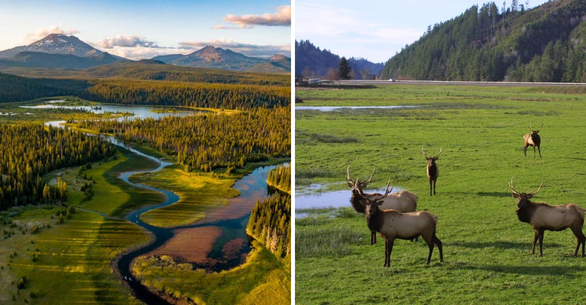
Wildlife Crosses When You Least Expect It
A majestic elk stepping onto the road makes for an incredible photo opportunity – unless you’re traveling 55 mph around a curve. The Rogue-Umpqua Scenic Byway passes through prime habitat for deer, elk, and other large animals that don’t respect traffic patterns.
Dawn and dusk bring the highest collision risk, yet these times offer the best lighting for photography. Travelers face a tough choice. One family encountered seven deer in a single ten-mile stretch during early morning, each appearance causing sudden braking and swerving.
Reduce speed during low-light hours, even if it feels frustratingly slow. Scan the roadside vegetation, not just the pavement ahead. Wildlife often travels in groups, so one crossing animal likely means more are following.
Pavement Ends Without Much Notice
Your GPS shows a continuous route, but it doesn’t distinguish between highway-quality pavement and rocky Forest Service roads. Many Oregon scenic routes transition from smooth asphalt to rutted gravel without warning signs or preparation distance.
Sports car drivers have learned this lesson expensively, scraping undercarriages on rocks or getting stuck in loose gravel. One couple in a rental sedan faced 15 miles of unpaved road after the pavement suddenly ended, damaging their oil pan on protruding stones. The rental company was not sympathetic.
Research surface conditions beforehand, especially for lesser-known routes. Forest roads may require high clearance or four-wheel drive. When pavement ends unexpectedly, assess honestly whether your vehicle can handle what’s ahead. Turning around beats expensive repairs.
Unexpected Detours Lead to Hidden Gems
Taking the scenic route can sometimes lead to unexpected detours, but these aren’t always a setback. Many travelers have found that these deviations uncover hidden gems such as secluded waterfalls or quaint towns. It’s the unexpected surprises that truly enrich the journey.
Imagine following a winding road, only to be led to a breathtaking vista that wasn’t on your itinerary. This spontaneous adventure offers a chance to discover new places and create lasting memories. Next time you find yourself on an unplanned path, embrace it. You might just find the trip’s highlight in the most unexpected place.
These detours remind us that travel isn’t just about reaching the destination – it’s about the moments in between. Taking time to explore off the beaten path allows you to connect more deeply with the landscape and local culture. Whether it’s a roadside café with the best pie you’ve ever tasted or a quiet overlook where you can pause and breathe, these surprises often become the stories you cherish most. So, keep an open mind, trust your curiosity, and let the road lead you somewhere unforgettable.
Dear Reader: This page may contain affiliate links which may earn a commission if you click through and make a purchase. Our independent journalism is not influenced by any advertiser or commercial initiative unless it is clearly marked as sponsored content. As travel products change, please be sure to reconfirm all details and stay up to date with current events to ensure a safe and successful trip.