A passenger’s late-night TikTok from a flight leaving Miami turned a routine climb to cruising altitude into a front-row seat to nature’s theater. Lightning stitched the horizon while Hurricane Erin churned below, casting an eerie, cinematic glow across the clouds.
The clip sparked a wave of fascination and debate among weather-watchers and aviation fans alike. Step inside the cabin window moment that made thousands pause, rewind, and look again.
A View Nobody Expected
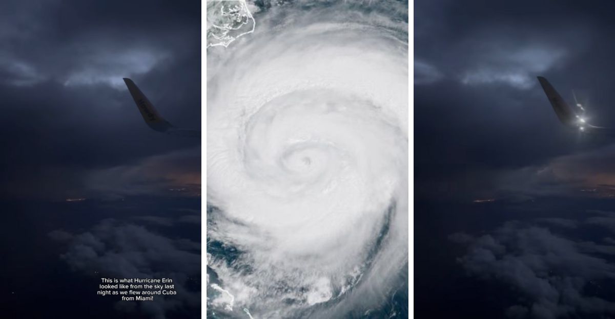
A late-night flight lifting out of Miami, Florida, gave passengers a glimpse few ever see: a hurricane from the sky. As the jet climbed toward its cruising altitude, flashes began to bloom beyond the windows, silent, white arcs threading through distant towers of cloud. The scene was both peaceful and alarming, a slow strobe revealing the power of Hurricane Erin churning far below.
Traveler @ericabarbour5 filmed seven seconds of that spectacle and uploaded it to TikTok. The short clip, captioned simply “Flying out of Miami last night, Erin lighting up the horizon,” spread fast through weather and aviation circles. Viewers replayed it frame by frame, debating how close the aircraft really was and whether lightning like that could appear so far from the eye of a storm.
At the time of the video, Erin was still a Category 2 hurricane traveling north-northeast off the U.S. coast. The National Hurricane Center reported sustained winds around 105 mph and heavy surf reaching beaches from the Carolinas to southern New England. Its center remained well offshore, but wide rainbands arced hundreds of miles across the Atlantic. Those outer bands are where lightning thrives, thin, towering clouds packed with mixed ice and water droplets that trade charge until they discharge in brilliant flashes.
That is what passengers likely saw: not the storm’s core, but its breathing edges. The view from altitude compressed distance, making safe margins appear perilously tight. From the ground, the same flashes looked like a flickering horizon beyond scattered showers.
Inside the Cabin
The TikTok footage is brief. A section of wing glows silver for an instant, then darkness returns. The cabin hums steadily. Lightning pulses again, outlining stacked clouds like stone columns. There is no turbulence in the frame, only contrast, quiet inside, chaos outside.
People watching online compared it to time-lapse photography, a kind of accidental cinema produced by physics. Others noted how the plane seemed to hover at the border between calm and danger. Aviation meteorologists later confirmed that the flight path, based on typical Miami departures, would have kept the jet more than a hundred miles from the nearest convective cell. The illusion of nearness comes from darkness: without surface cues, the eye cannot measure distance in the night sky.
Commercial routes leaving Florida change constantly during hurricane season. Dispatchers monitor real-time radar and satellite feeds, adjusting headings and altitudes to skirt active thunderstorm clusters. Standard practice requires crews to avoid cumulonimbus cells by wide margins, 20 nautical miles for ordinary storms, much more for tropical systems.
Pilots rely on onboard Doppler radar to visualize precipitation and lightning networks that mark electrified regions. Air-traffic controllers, working with the National Weather Service, maintain “clean corridors” between active weather zones. No scheduled airliner flies into a hurricane core; only NOAA’s specialized Hurricane Hunter aircraft enter those environments for research.
That coordination means what looks like proximity on social media is usually perspective. What viewers interpret as a brush with danger is often a carefully calculated detour.
The Science Behind the Flashes
Lightning inside hurricanes follows its own geography. The eye itself is often quiet; the violent electricity occurs in outer rings where updrafts stretch 40,000–50,000 feet high. Ice particles collide, generating charge separations that discharge as long, branching bolts. From above, those flashes light entire cloud fields, spreading laterally across the anvil tops.
Scientists track this activity through instruments such as the GOES-16 Geostationary Lightning Mapper, which maps flashes across the hemisphere in real time. Data from storms like Erin help refine forecasts of intensification. When lightning frequency spikes, it often signals renewed convection near the core, a clue forecasters watch closely.
The video’s rhythm matched that pattern: clustered bursts separated by darkness, typical of a storm reorganizing as it moved northward over warm water.
While passengers witnessed the drama from above, residents along Florida’s Atlantic coast experienced the storm’s indirect reach. Erin’s outer energy sent long-period swells toward the shoreline, producing rip-current advisories and beach-closure warnings from Miami-Dade through the Space Coast. Lifeguards raised red flags, and local weather offices urged swimmers to stay within patrolled zones.
The storm never threatened landfall in the state, but its presence changed the sky and the sea, humid mornings, fast-moving showers, and a restless surf that hinted at larger forces offshore. For most Floridians, Erin was felt rather than seen: a pulse of tropical energy that stirred the atmosphere without crossing the coast.
The Social-Media Spiral
Back online, the TikTok clip became a magnet for speculation. Aviation fans tracked possible flight numbers using open radar sites; meteorologists debated whether the lightning originated from the storm or nearby convection. Artists remixed the footage with music, turning it into a visual poem about scale and silence.
What kept viewers returning was contrast, one small window framing an event measured in hundreds of miles. The combination of ordinary travel and extraordinary weather turned a routine takeoff into shared wonder. Many commenters described watching it on loop, trying to imagine the feeling of being suspended above that much power.
The clip’s popularity reflects a broader truth: people crave sensory proof of natural forces they usually meet only through maps and bulletins. A satellite image shows data; a passenger video shows experience. For meteorologists, such moments are teaching tools. They remind the public that distance matters, that lightning can strike far from a storm’s eye, and that flights are engineered to stay far beyond danger even when optics deceive.
The National Weather Service later used similar imagery to explain why outer bands extend influence well past forecast cones. A single storm can reshape weather patterns across entire regions, raising tides in one state, spawning showers in another, altering jet-stream paths far to the north.
Hurricane Erin in Context
Erin formed over the central Atlantic from a tropical wave, strengthening quickly as it passed through warm waters. By late August 2025 it reached Category 4 before weakening near cooler currents. Even after that, it maintained a large circulation that disrupted marine routes and produced heavy surf along the Eastern Seaboard.
Climatologists noted that the season’s sea-surface temperatures were among the highest on record, supporting longer-lived storms. They also pointed to Erin’s extended lightning footprint as evidence of robust convection late in its life cycle. Though not catastrophic, the storm became a case study in how energy moves through the atmosphere, visible in every flicker that passenger filmed from the departing jet.
What made the video stand out was its simplicity: no commentary, no editing, just light in darkness. It compressed an entire meteorological system into seconds and offered a perspective that radar cannot. For many, it reframed hurricanes not as satellite spirals but as living architectures of cloud and electricity.
There was also reassurance in seeing the airplane steady through it all. The footage demonstrated the margin between spectacle and safety, the unseen network of pilots, dispatchers, and meteorologists working together to keep flights smooth even when storms dominate the region.
After the Share
Within days, the clip migrated to mainstream outlets and science forums. Weather educators used still frames to discuss charge separation. Flight instructors cited it when teaching situational awareness at altitude. What began as an impulsive post became a bridge between science and everyday observation.
Will the next storm produce another viral window? Almost certainly. Modern airspace and mobile cameras guarantee that someone, somewhere, will capture light moving through cloud at scale. Each time, the cycle repeats: awe, analysis, understanding.
From a single passenger seat above Florida, the world saw lightning mark the boundary between human travel and natural motion. Erin continued its path into the North Atlantic, fading over cooler waters but leaving traces in tide gauges, humidity charts, and digital memories.
For scientists, the data enrich models. For travelers, the memory reframes the ordinary climb through clouds. And for everyone who paused that TikTok to study a frame of light, the lesson endures: safety and spectacle often share the same sky.
Dear Reader: This page may contain affiliate links which may earn a commission if you click through and make a purchase. Our independent journalism is not influenced by any advertiser or commercial initiative unless it is clearly marked as sponsored content. As travel products change, please be sure to reconfirm all details and stay up to date with current events to ensure a safe and successful trip.